Punam Phuyal

The North face of Mount Everest is in the Tibet Autonomous Region, China, while the south face of Everest is in Nepal. Standing on the boarder between China and Nepal, the highest peak in the world spreads its beauty from both northern and southern faces. The popularity of south Everest base camp and north Everest base camp has attracted millions of trekkers in the globe. The technical climbing to summit is ongoing since 1953 AD from the south face and 1960 AD from the north face of mount Everest.
There are four Mt. Everest northeast ridge routes (Norton couloir, hornbein couloir, three steps and three pinacles) with different challenges. These routes are well established for Everest expedition from north face. Each route has its own history:
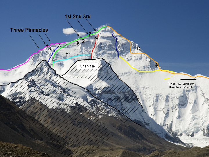
Norton couloir (the red line in image 1) is also known as great couloir (route) named after a British climber Edward F. Norton, the British expedition lead member, 1924 AD. The climber Edward F.Norton, reached on elevation of 8572.8 m and returned without reaching the summit. He ascends to the couloir to avoid the risk from the windswept ridge. The challenging, narrow and steep Norton couloir extends to 8698m. It is the safest route to avoid the dangerous ridge before stepping to the summit. The coulior was further used by Reinhold Messner, Italian climber to attempt the Mt. Everest summit from north face in 1980 AD.
Hornbein couloir (dark blue line in image 1) is the narrow and steep route that extends from 8000m to 8498m. These gully was named after Thomas Hornbein, an American climber. He and his friend, Willi Unsoeld, the member of American Mount Everest Expedition 1963 AD, inholds challenging routes along with the discovery of Hornbein couloir in 22 May 1963 AD.
Three steps (1st, 2nd and 3rd in image 1) are the rocky steps of Mt. Everest northeast ridge route. Each of these steps are significant for climbing through the normal route to Everest summit from north face.
The first step is difficult with its large boulders as obstacles located at 8564 m/ 28097 ft. in death zone. It is the most dangerous part where more than 200 climbers have lost their life. Among which the “Green boots” the dead body probably of Tsewang Paljor, a member of an Indo Tibetan Police Expedition team, 1996 AD has become a landmark on north route. Tsewang Paljor and the team faced blizzard and lost their life while descending from the summit.
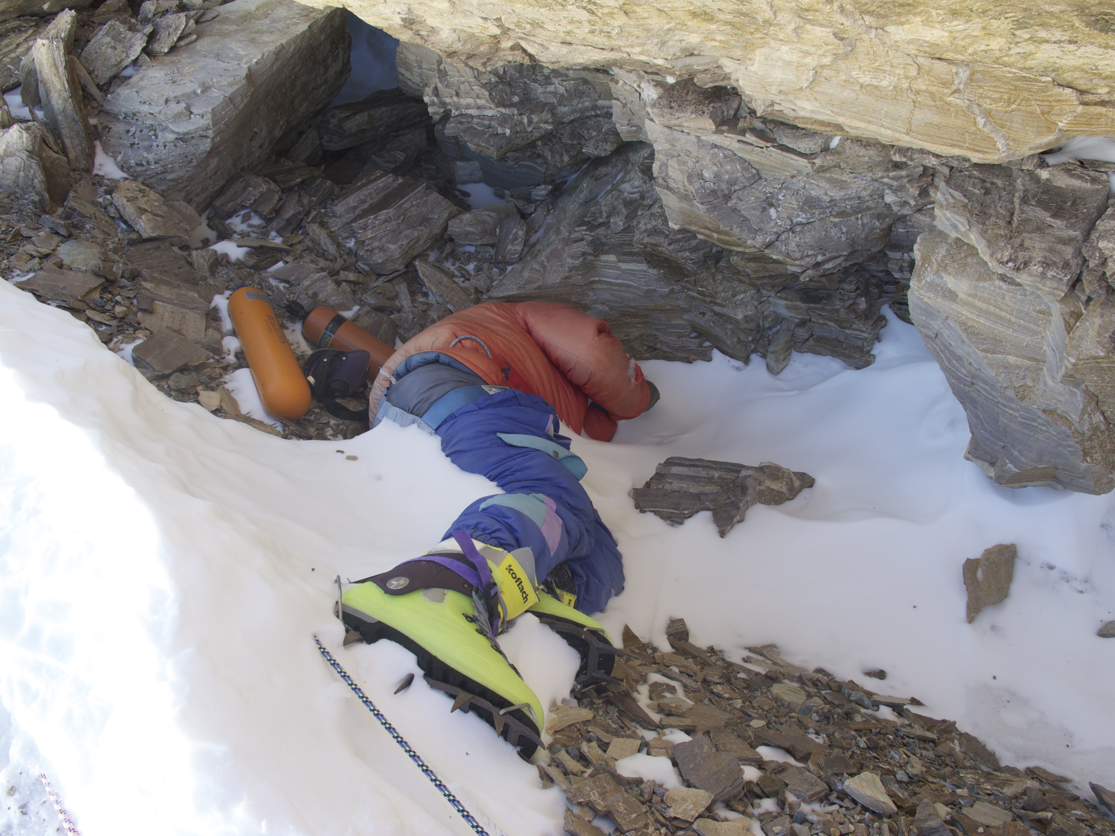
The curve body with neon green boots, blue pant and red jacket resting under the boulder of first step was recorded on video of Matt Dickinson. In 2006, the British mountaineer David Sharp also died in green Boot’s cave due to hypothermia. Later on the green boot was moved from the cave to the readily visible place by China Tibet Mountaineering Association in 2014 AD to reduce attention of climber towards the corpse.
The second step is located at 8610 m/ 28248.8 ft. with climbing height of 40 m with steep vertical sections. It was first climbed by Chinese climber Wang Fuzhou, in 1960 AD as the first climber to reach the summit from north face of Mount Everest. The three climbers (Wang Fuzhou, Gonpo and Qu Yinhua) from 1996 Chinese Mount Everest Expedition team reached the summit from northern edge of Everest.
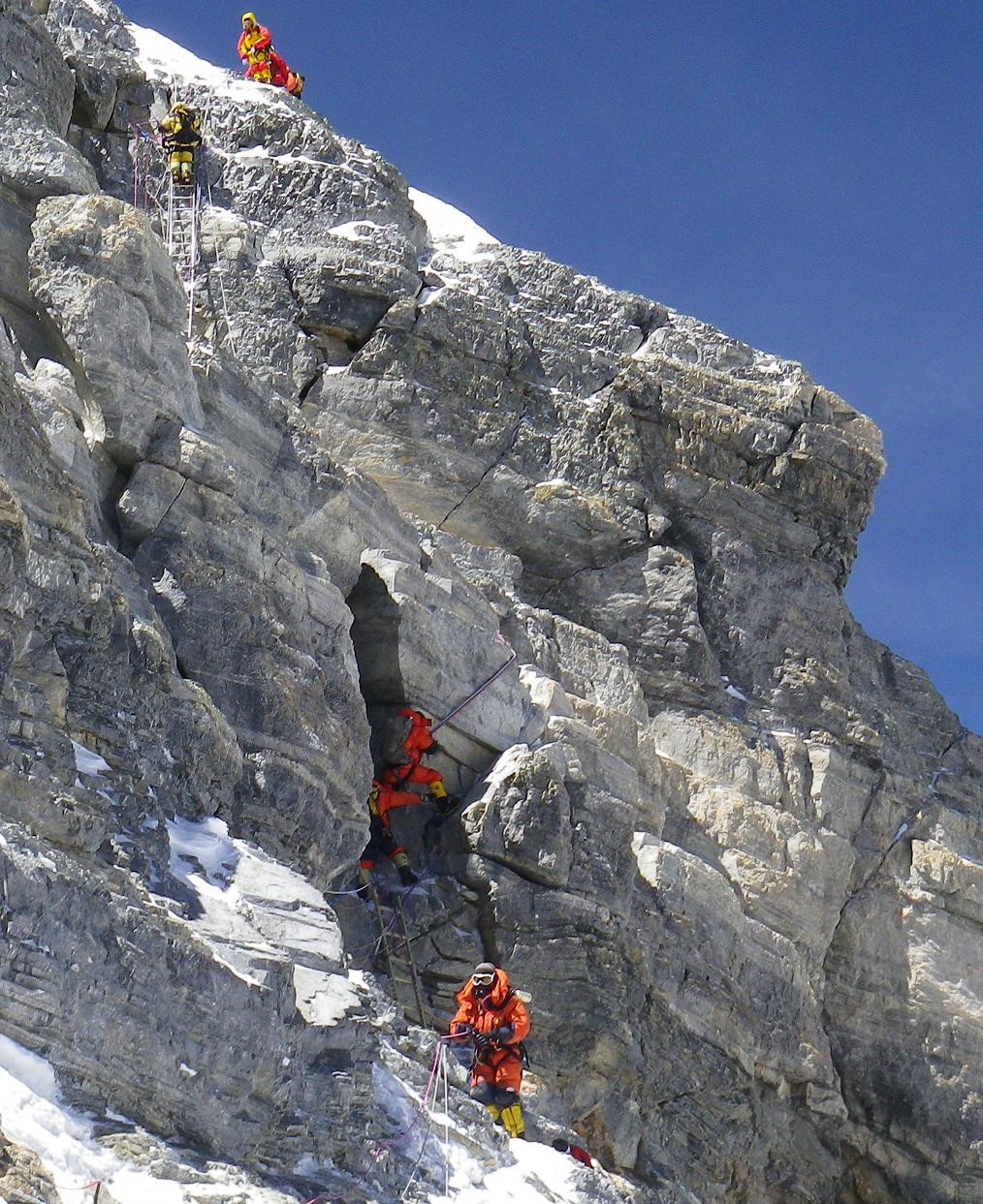
The third step is the easiest part of three step with 10 m height leading to the summit snowfield. The climbers passing the first and second step can easily cross the third step to conquer the summit.
The three pinacles (purple line in imalge 1) are the three steep rocks on northeast ridge of Everest. First, second third pinacles are located around 7800m, 8100m and 8200 m respectively in death zione. Passing through these pinacles is a challenge for mountaineers. The north ridge route of mount Everest continues to three steps after passing three pinacles. Mostly, the normal route to summit avoid three pinacles due to frequent fatalities and serious condition of climbers.Peter Boardman an english mountaineer and Joe Tasker a British climber loss their life in 1982 AD while passing through pinacles.
The new Zealand mountaineers: Russell Brice and British mountaineer Harry Taylor successfully climbed three pinnacles in 1988 AD. Eventhough the repeated death of mountaineers and the difficult path suggest to avoid the pinacles route to summit.
Yes, the north side of Everest is harder as compared to south side of Everest. The normal route to climb Everest via the north face starts from north base camp (5150 m), and continues to intermediate camp, Advanced base camp (ABC) 6400 m, North Col (Camp I) at 7020 m, Camp II at 7700 m, Camp III at 8300 m, and final steps to the summit through three steps on the northeast ridge. The second step is very challenging before reaching the summit. The steep slopes of northest ridge in death zone is the hardest part for mountaineers.
The strong wind, freezing temperature, difficult terrain with steep vertical rocks above 8500 m makes expedition much harder in north face of Mt. Everest. It takes around 50 days to complete Everest expedition north. It takes a long time for acclimatization that involves going to higher elevation and returning to lower elevation.
Several attempts has occurred to reach the summit of Mount Everest from north face since 1921 AD. Many mountaineers loss their life on which 98 corpse are recorded in north face of Everest until 2024 AD . The first successful attempt to the summit of Mount Everest via north ridge was done by Wang Fuzhou, Gongbu and Qu Yinhau, the 1960 Chinese Mount Expedition team. Since then several successful summit has occurred.
Famous view and landmarks on north face of Mount Everest
Final words on north face of Everest !
North face of Everest is a technical terrain with rocky ridge. The strong winds, colder conditions and difficult descent remain as a challenge for mountaineers. The north face is visible from Tibet. The clear face of northedge can be seen from Rongbuk monastery aswell. The harder terrian and difficulty in rescue have made north face less popular than the south face.
...


